Mapping and tracking gas flaring from space

Using publicly available satellite remote sensed data from VIIRS, WebGeospatial and Sentido Labs have designed and implemented the Nigerian Gas Flare Tracker. This web GIS tool locates gas flares and calculates the volume of gas flared using satellite data. It also calculates other useful metrics such as the value of flared gas and the amount of c02 released. It is aimed at assisting the Nigerian government in its regulatory duties, whilst shining a light on this wasteful and damaging practice. The 2018 upgrade of the gas flare tracker, first put in place in 2015, uses the findings of Rory’s recent MSc Thesis which calibrates VIIRS Nightfire satellite data with official reporting to come up with surprisingly accurate estimates of gas flaring volumes on local and national scales.
Providing government environmental regulators with web GIS systems
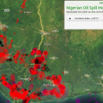
Working closely with the Nigerian government regulator NOSDRA and as part of a DFID funded project implemented by Stakeholder Democracy Network, WebGeospatial managed the implementation and delivery (with Sentido Labs) of the Oil Spill Monitor. This web-based GIS system, in place since 2015, allows Nigerian government regulators to manage and map the data they hold on the many hundreds of oil spills that plague the Niger Delta every year. All the data to be queried extensively and generates dynamic reports on company responsibility, the cause of oil spills, and other useful metrics.
Online election monitoring and mapping
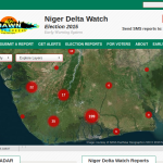
WebGeospatial worked with Stakeholder Democracy Network to map and monitor the 2011 and 2015 Nigerian elections. The project combined an Ushahidi citizen mapping deployment, connected to a communications hub on the ground in the Niger Delta, and with teams of election observers at polling stations. The resulting Niger Delta Watch platform still lists reports of voting irregularities, violence and intimidation from the 2015 elections, verified and put on the map for the world to see.
Investigating deforestation using satellite data

As part of Mighty Earth‘s ongoing drive against deforestation in Asia, WebGeospatial helped by identifying recently cleared rain-forest in Cambodia. Using data available through the Global Forest Watch initiative, rain-forest that had been recently cleared for rubber plantation was isolated and mapped across the whole country to identify where to focus local investigative work on the ground.
Mapping factory conditions in Asia
Working with partners NOCTIS, WebGeospatial developed a data visualisation prototype using Carto, dxcharts.js and alasql.js that allowed the client to visualise and explore their data on worker conditions across Asia. The project included the delivery of animated maps and data-bound charts and graphs that would allow companies to make informed decisions as to which factories to engage with, based on the experiences of the workers in those factories.